He Roman empire It was a civilization Ancient Age who controlled much of Europethe north of Africa and Middle East from the year 27 BC to 476 AD.
A team of researchers managed to develop a digital map that radically changes what was known about the roads of the Roman Empire.
It was done thanks to the database Itiner-eand the results of the work were published in the journal Scientific Data.
From the preparation of the map, we detected more than 100,000 extra kilometers of ancient roadswhich doubles almost everything that was thought about the route network.
“The findings increase the known length of the empire’s road system by more than 100,000 kilometers,” said those responsible for the study in a statement released by the publisher. Springer Nature.
This data modifies the way in which the mobility in ancient times and revalues the Roman footprint in the modern landscape.
The project was led by Tom Brughmans, Pau de Soto and Adam Pazouttogether with scientific institutions from several European countries.
Roman routes have fascinated for centuries, but a good part of them was buried under recent cities, cultivated fields and changing landscapes.
For decades, available maps offered only part of the picture, and many regions remained in doubt.
The lack of complete digitalization was a problem for understanding the functioning of the empire.
Specialists had to resort to fragments, stories and scattered findings, which limited studies on administration, commerce and even ancient public health.
The coordination of the digital record implied a new challenge: gathering each fragment, comparing archaeological sources, ancient maps, historical descriptions and making a synthesis that serves both history and social and economic modeling.
The goal went beyond calculating distances. Itiner-e set out to connect the dots, show real connections between regions and identify real junctions, forks and differences between main and secondary routes in the territories of the former empire.
“No one had put together such a complete and open access digitization of Roman roads before,” highlighted the team of researchers.
The group of scientists combined satellite technology, archaeological archives, topographic maps and historical sources. This is how Itiner-e was born.
It is a digital database that compiled 299,171 kilometers of roadsand exceeded the traditional estimate of 188,555 kilometers by more than 100,000.
The difference in the total sum is due to a special focus on the Iberian Peninsula, Greece and North Africa.
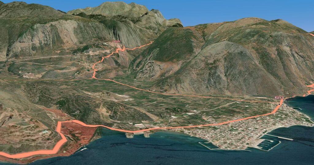
Building the map forced us to rethink the layout: digital roads now respect real geography, following curved routes in mountains, as the ancient Romans did.
Itiner-e includes 14,769 road sections, with 103,478 kilometers classified as main routes and 195,693 as secondary roads. Each section defines a section determined by intersections, cities or natural boundaries.
The level of precision is variable: only 2.7% of the routes gather direct and precise evidence. 89.8% have probable data and 7.4% are routes reconstructed from patterns and fragments.
The researchers commented that the Itiner-e base can now be used to investigate the influence of Roman roads on connectivity, administration, migration and disease transmission in the empire.
This opens the way to new questions about how the roads favored military expansion, trade and Roman cultural diffusion.
The team recommended delving deeper into the chronological dimension, since the database does not yet show how the routes varied over the centuries.
The ability to capture historical transitions remains a pending task for future research.
The report highlighted that most of the routes still do not have direct archaeological support, but that the base provides the best approximation available to any researcher.
“Itiner-e represents the most accurate and complete digitization to date, but it also exposes gaps in the current understanding of the roads of the empire,” the scientists highlighted.