4.0 magnitude earthquake shakes Chiapas
The National Seismological Service reports a magnitude 4.0 earthquake on May 21 at 8:49 a.m.
Epicenter: 56 km south of Ciudad Hidalgo, Chiapas Latitude: 14.17; Length: -92.15; Depth: 10 km
So far, no damage or victims have been reported. Authorities maintain preventive monitoring in the region.
Morning seismicity report for this Thursday, May 21, 2026
The National Seismology reports several earthquakes recorded during the early morning and early hours of this May 21, 2026.
Where did the earthquakes occur?
Most of the movements were detected in the south of the country, mainly in the states of Chiapas, Oaxaca and Guerrero. There was also seismic activity in Colima, Baja California Sur and Sinaloa.
What magnitude were they?
- The magnitude of the earthquakes varies between 1.4 and 4.1 degrees.
- The strongest, of magnitude 4.1, occurred near Ometepec, Guerrero, around 04:54 hours.
- Other relevant earthquakes:
- 4.0 south of Ocozocoautla, Chiapas, at 05:27.
- 4.0 southwest of Ometepec, Guerrero, at 01:46.
At what depth did they occur?
- Depths vary from 3 km to more than 160 km.
- Most were located between 10 and 130 km deep.
What does this mean?
- Earthquakes of magnitude less than 4.5 are usually perceived slightly by the population or may go unnoticed, depending on the distance from the epicenter.
- No reported earthquake exceeds magnitude 4.1, so it is unlikely they caused damage.
Simple summary
- More than 20 minor earthquakes are recorded during the early morning and morning hours of May 21.
- Guerrero, Oaxaca and Chiapas are the areas with the greatest activity.
- All the earthquakes are of low magnitude and do not represent a major risk to the population.
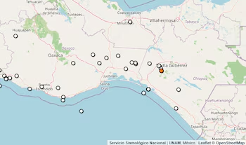
The National Seismological Service announced a 4.0 magnitude earthquake at 05:27 hours. The epicenter is located 30 kilometers south of Ocozocoautla, Chiapas, at coordinates 16.497° latitude and -93.436° longitude, with a depth of 169.9 kilometers.
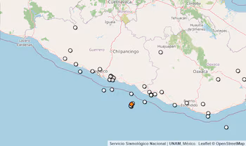
The National Seismological Service reported a 4.1 magnitude earthquake at 04:54 hours. The epicenter is located 93 kilometers southwest of Ometepec, Guerrero, at coordinates 15.98° latitude and -98.876° longitude, with a depth of 16 kilometers.
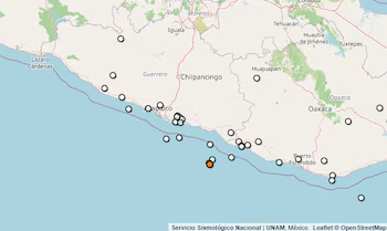
The National Seismological Service reported a 4.0 magnitude earthquake at 1:46 a.m. The epicenter is located 99 kilometers southwest of Ometepec, Guerrero, at coordinates 15.919° latitude and -98.884° longitude, with a depth of 18.7 kilometers.
Mexico is located in a seismic zone, because five tectonic plates are located beneath the national territory: Caribbean, North America, Pacific, Rivera and Cocos. For this reason, the constant interaction between these five plates places the country in an area of high seismicity.